How to Edit GPS Metadata on Multiple Photos in Windows

Do you have a folder full of photos with missing or incorrect GPS metadata that you need to fix? Don’t worry, you’ve come to the right place! Below is a step-by-step guide on how to edit GPS coordinates on multiple photos for free in Windows.
Table of Contents
Step By Step
1. Download and Install ExifTool
ExifTool is a very useful free software created by Phil Harvey for reading, writing and editing metadata on image files. If you already have ExifTool installed on your computer, you can skip this step.
1. Download ExifTool on your computer (Windows executable version).
2. Unzip the file on your computer and rename the executable from “exiftool(-k).exe” to “exiftool.exe”
3. Copy exiftool.exe to the C:/Windows directory.

2. Get GPS Coordinates
There are many different ways to get GPS coordinates, but the easiest way is just to use Google Maps.
1. Open Google Maps.
2. Search the map for the location you want to use on your photos.
3. Right-click on a point in the map and click on the GPS coordinates (first item in the menu). This will copy the GPS value to your clipboard.
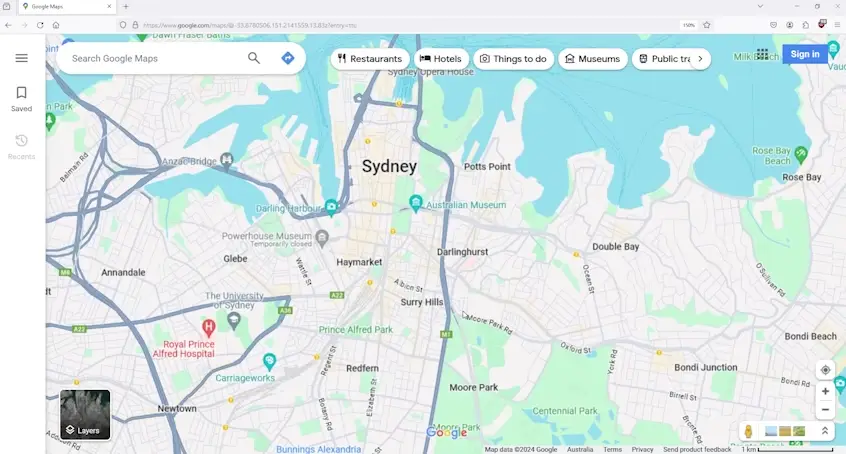
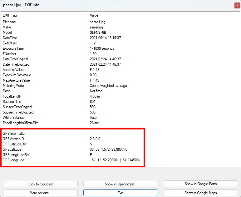
In the above example, the GPS coordinates copied was “-33.88377, 151.21450“. It’s important to have some basic understanding of what these numbers mean before going to the following section.
- These values are in Decimal Degrees (DD) format.
- -33.88377 is the Latitude value
If you have a positive Latitude number, it means that the location is situated North of the equator line. If you have a negative number, then it’s situated South of the equator line. This is referred to as the “GPS Latitude Ref” in the EXIF standard. - 151.21450 is the Longitude value.
If you have a positive Longitude number, it means that the location is situated East of the Prime meridian line (Greenwich). If you have a negative number, it’s situated West of the Prime meridian line. This is referred to as the “GPS Longitude Ref” in the EXIF standard.
3. Batch Processing Photos in ExifTool
Before proceeding this with step make sure you have the following information handy:
- Folder path where your photos are stored
- GPS Coordinates you want to apply to the photos
- GPS Latitude value
- GPS Latitude Ref (N or S)
- GPS Longitude value
- GPS Longitude Ref (E or W)
1. Open Command Prompt.
You can use the shortcut Windows Key + R, then type “CMD” and press OK.
2. Edit the following command in notepad. Replace <latitude>, <latitude ref>, <longitude>, <longitude ref> and <folder path> with your own information.
exiftool -GPSLatitude=<latitude> -GPSLatitudeRef=<latitude ref> -GPSLongitude=<longitude>
-GPSLongitudeRef=<longitude ref> <folder path>
3. Type the edited command into Command Prompt and press Enter.
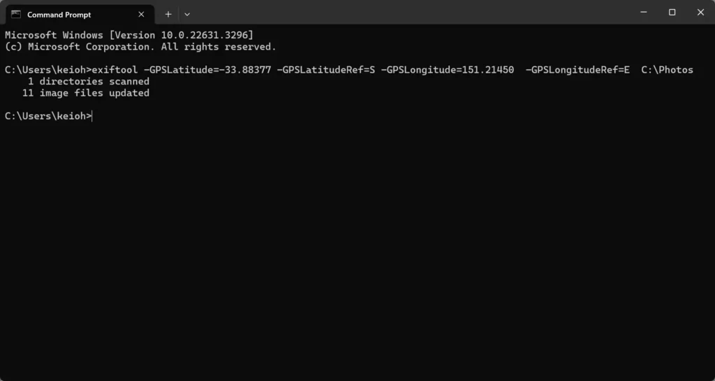
In this example, we are using the following command:
exiftool -GPSLatitude=-33.88377 -GPSLatitudeRef=S -GPSLongitude=151.21450 -GPSLongitudeRef=E C:\PhotosIf you check the EXIF metadata on those photos, you should see that they all have the same GPS coordinates now.
How to Edit GPS on Individual Photo Files
If you don’t want to edit the GPS metadata on all the photos in the folder, you can simply specify the file paths of the photos instead of the folder path:
exiftool -GPSLatitude=<latitude> -GPSLatitudeRef=<latitude ref> -GPSLongitude=<longitude>
-GPSLongitudeRef=<longitude ref> <file path>
For example:
exiftool -GPSLatitude=-33.88377 -GPSLatitudeRef=S -GPSLongitude=151.21450 -GPSLongitudeRef=E "C:\Photos\Photo1.jpg" "C:\Photos\Photo2.jpg" "C:\Photos\Photo3.jpg"This will only edit the GPS coordinates on Photo1.jpg, Photo2.jpg and Photo3.jpg in the C:\Photos folder.
How to Stop ExifTool from Making Backup Files
When you use ExifTool to modify the GPS coordinates (or any metadata) in a photo, it creates a backup of the original file by default. This is a safety feature to prevent accidental loss of data. It keeps the original in case you decide you want to undo your changes.
However, if you’re confident in your changes and don’t want ExifTool to save these original backups, you can tell it not to. To do this, you use the “-overwrite_original” option in your command.
exiftool -overwrite_original -GPSLatitude=<latitude> -GPSLatitudeRef=<latitude ref> -GPSLongitude=<longitude> -GPSLongitudeRef=<longitude ref> <folder path>Why Are Your Photos Missing GPS Metadata?
If you are wondering why your construction photos don’t have any GPS coordinates in the metadata, there are several common reasons why this may be the case:
1. Photos were shared to you via messaging or social media apps
When photos are shared through majority of chat and social media platforms, like WhatsApp, Snapchat, or Telegram, the platforms often strip away EXIF metadata including GPS coordinates for privacy and security reasons. This automated process is designed to protect users’ location information from potentially falling into the wrong hands.
2. Lack of GPS signal where the photos were taken
GPS signals can sometimes struggle to reach devices through dense materials or in environments where direct access to the sky is obstructed. This includes not only indoor spaces within buildings and under construction sites, where metal and concrete abound, but also outdoor areas with significant overhead obstructions like dense foliage, urban canyons formed by high-rise buildings, or even under bridges. In such situations, devices may not be able to acquire a stable GPS signal, resulting in photos that lack GPS metadata.
3. Location Services was disabled on the device that took the photos.
Another common reason photos don’t contain GPS information is that Location Services was disabled on the device that was used to take the photos. This could be a device setting or an App permission setting.
Use SiteCam to Improve Your Construction Photo Documentation Process
If your team is looking for an easy and fast camera app to capture and manage project photos with GPS information intact try SiteCam for free today!
Related Articles
- Project Management for Architects
- Practical Guide to LiDAR for Construction
- How to Create Construction Progress Reports
- Architect’s Guide to Site Visits and Observations
- Construction Site Inspections – A Complete Guide
- 10 tips for taking better site photos
- The Importance of Photo Documentation in Construction
- What is rough-in stage in construction?
- How to be a great building cadet